Inside the Park Place Concept Plan in Oregon City
Oregon City's Park Place Concept Plan guides roughly 480 acres into a North Village and South Village with about 1,459 dwelling units. Here is how it shapes land like 16868 S Livesay Rd.
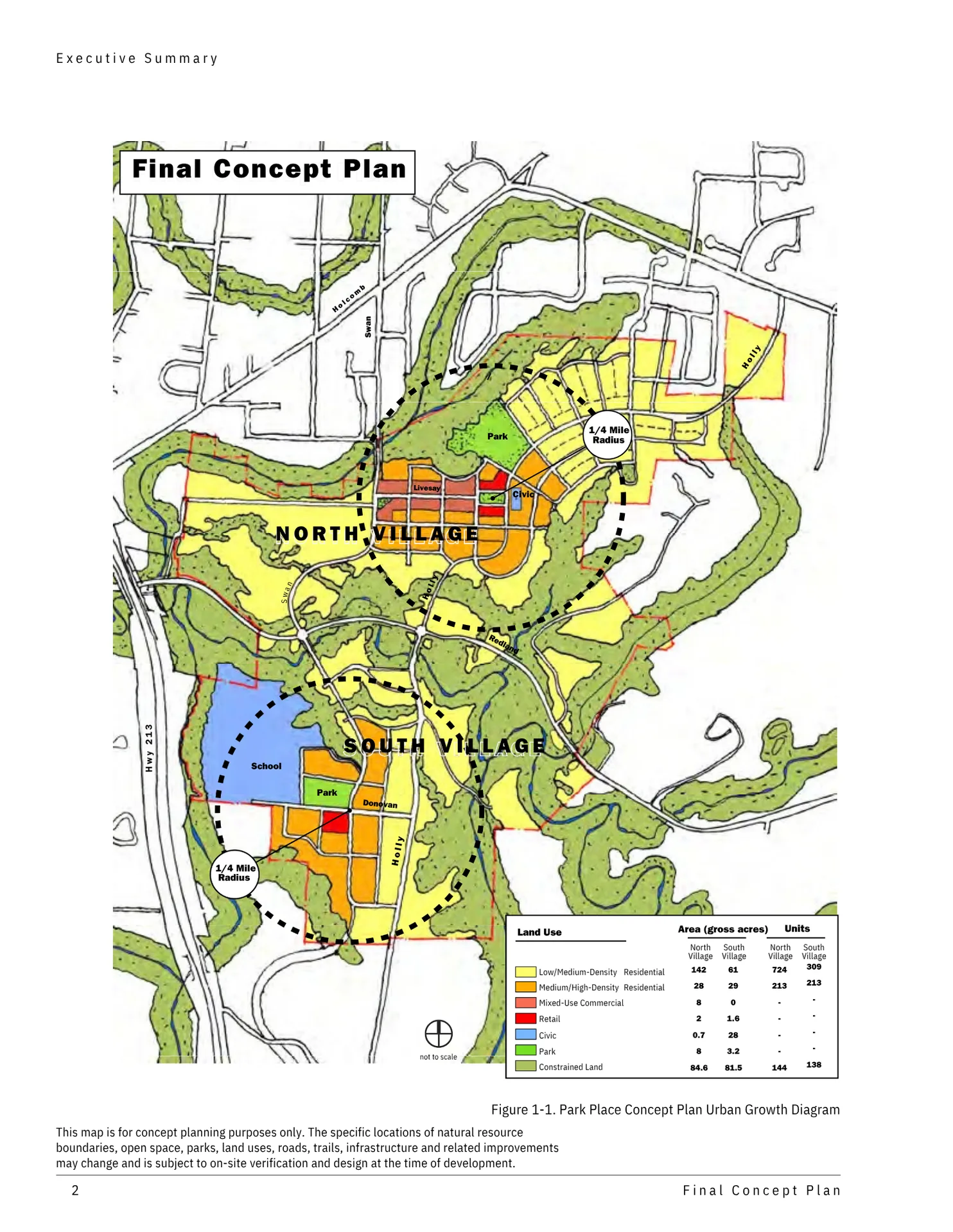
The Park Place Concept Plan is Oregon City's long-range blueprint for roughly 480 acres of rural land east of the city center that entered the Portland metro urban growth boundary in 2002. For anyone looking at 16868 S Livesay Rd, it is the single most important public document about the neighborhood's future.
How the plan works
Adopted by Oregon City in 2008, the concept plan organizes the planning area into two distinct mixed-use neighborhoods: the North Village and the South Village. Together they anticipate about 1,459 new dwelling units, neighborhood-oriented commercial nodes, a civic institution, and housing at a mix of types and affordability levels. Neighborhood park land is part of the plan as well, with an 8 to 10 acre community park and a 3 to 5 acre neighborhood park referenced in later planning.
- North Village and South Village split the planned growth.
- Commercial nodes are planned at neighborhood scale, not big-box.
- Two primary north-south connections link Holcomb Blvd and Redland Rd.
- Roads in and near the area include S Holcomb Blvd, S Redland Rd, S Holly Ln, S Barlow Dr, and S Livesay Rd.
The 2025 code update matters
Concept plans describe vision; zoning codes implement it. In January 2025 the Oregon City Commission adopted Park Place Concept Plan Code Amendments, moving the 2008 plan into clear-and-objective development standards. That is the difference between "someday" and "permitted," and it is why this corner of Oregon City reads differently to developers than it did even a few years ago.
What it means for 16868 S Livesay Rd
The property sits in the southeastern portion of the planning area, near S Livesay Rd and S Redland Rd, today zoned FU-10 by the county. The concept plan is the reason the land's future is likely low or medium density: on annexation, city zoning replaces the county holding zone, and the concept plan is the city's stated intent for how this area should grow.
None of this is a guarantee of timing or density. City process, service funding, and market conditions all play a part, and buyers must verify all information. But the documents themselves are public, and worth reading before you underwrite anything. The city maintains the full plan and the 2025 amendment files.
Key takeaways
- The concept plan covers roughly 480 acres divided into two villages.
- Planned capacity is about 1,459 dwelling units plus commercial and parks.
- Implementable code arrived in January 2025.
- 16868 S Livesay Rd sits inside the planning area near S Redland Rd.