What FU-10 zoning means for 7.89 acres in Oregon City
FU-10 is Clackamas County's Future Urbanizable 10-acre district, a holding zone for land inside the urban growth boundary. Here is what it means for 16868 S Livesay Rd.
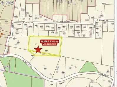
FU-10 stands for "Future Urbanizable, 10-Acre District," and it is Clackamas County's way of holding land inside the urban growth boundary until urban services arrive. The designation sets what the two parcels at 16868 S Livesay Rd can do today, what they become on annexation, and why that matters for a buyer.
The short version
FU-10 keeps rural land developable at urban densities later, without allowing urban-density development now. When a city annexes the land, it applies its own zoning to replace the county's. For this property, the likely result is low or medium density residential zoning.
What FU-10 actually is
Clackamas County's Zoning and Development Ordinance, Chapter 314, creates the FU-10 district for land shown as "Future Urbanizable" on the county's comprehensive plan map. The purpose is preservation, not restriction for its own sake: these parcels stay rural and low-impact until water, sewer, and roads can support urban growth.
- Each lot allows one single-family dwelling, manufactured dwelling, or accessory units.
- Farm uses and livestock are permitted, as in the county's other rural residential districts.
- The minimum lot size is 10 acres, so no urban-density subdivision is possible while FU-10 stays in place.
- In practice, the parcels here are two lots totaling 7.89 acres, so detailed parcel questions belong in the verification step.
What changes at annexation
County zoning applies only while land remains unincorporated. On annexation, Oregon City replaces the FU-10 designation with a city zone, typically through the annexation application or a concurrent zone change. Oregon City has followed this exact path before: previously annexed FU-10 properties have been rezoned to low density residential, and a school district parcel was converted to campus industrial zoning.
For buyers, the practical question is timing and certainty. Annexation requires city action, service planning, and public process. The Park Place Concept Plan, adopted in 2008 and updated with implementable code in January 2025, is the city's blueprint for what happens in this area when that conversion occurs.
What this means for 16868 S Livesay Rd
The property's future is likely low or medium density upon annexation, and buyers must verify all information, including future development density. The two parcels total 7.89 acres and sit within the concept plan area, near the intersection of S Livesay Rd and S Redland Rd.
That combination, a holding zone inside a planning area with adopted urban expectations, is the reason this listing is an opportunity story rather than a straight acreage sale. The adjacent property, held by a different seller, is also listed, which raises the possibility of alternate access and 25+ contiguous acres for a buyer assembling a larger site.
Talk through the county records and the city's annexation timeline with the listing agent before underwriting anything. The documents are public, and Danielle's team will point you to the right contacts.
Key takeaways
- FU-10 permits one dwelling and farm use now, with 10-acre minimum lots.
- Annexation is the trigger that replaces FU-10 with city zoning.
- The likely direction here is low or medium density.
- Buyers must verify density, service timing, and parcel details independently.